Of late, many meteorological centers around the world have been attempting weather prediction on extended range (7-30 days) time scales. The extended range prediction is aimed at filling the gap between medium-range weather forecasting and seasonal forecasting. It is well known that the weather forecasting from daily to medium range (up to 10 days) time scales relies mainly on the memory of atmospheric initial conditions and on the other hand, the seasonal forecasting depends largely on the predictability of ocean variability (e.g., ENSO) and its impact on the global and regional atmospheric circulation. Extended range forecasting is therefore believed to be short enough that the atmosphere still has a memory of its initial condition and long enough that the ocean variability could have an impact on the atmospheric circulation. Part of the predictability on this time scale (particularly in Asia) is linked to a well known tropical phenomenon known as the Madden Julian Oscillation (MJO). Show Details...
Based on the model forecasts available as on 29 January, the following is the outlook for the next four weeks:
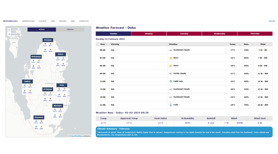
Rainfall: Model Forecasts indicate some chances for rainfall activity in the second week (07 – 13 Feb). However, chances for some localized rainfall cannot be ruled out in the remaining weeks.
Wind: Model predicted weekly mean wind patterns show no chances for the occurrence of Shamals in Qatar in the next four weeks (31 Jan – 27 Feb), though Northwesterly winds are expected to prevail in the next four weeks.
Maximum temperature: The daytime (maximum) temperatures are expected to be below normal to near normal in the next four weeks (31 Jan – 27 Feb). The weekly mean maximum temperatures are likely to be in the range of 20–28°c and with generally higher temperatures over the southern parts.
Minimum temperature: The nighttime (minimum) temperatures are expected to be below normal in the next four weeks (31 Jan – 27 Feb). The weekly mean minimum temperatures are expected to be in the range of 14-20°c.
Relative Humidity: The relative humidity values are expected to be below normal in the next four weeks (31 Jan – 27 Feb). The weekly mean relative humidity is expected to be in the range of 40 – 65%
The maps shown below are self-explanatory and are expected to provide a general outlook of expected weather for the next four weeks. However, for day to day weather forecasts one should refer to the Forecast section of QMD website. Given that we update these outlooks every Thursday, the forecasts for the later part of the month may vary and so we encourage users to check our updated outlooks every week.